By BBC (World News) | Created at 2024-09-30 17:00:15 | Updated at 2024-09-30 21:29:27
6 hours ago
By BBC (World News) | Created at 2024-09-30 17:00:15 | Updated at 2024-09-30 21:29:27
6 hours ago

 Getty Images
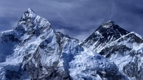
A new study says Mount Everest is about 15 to 50m taller than it would otherwise be, thanks to erosion from a river network
Mount Everest is 15-50m taller than it would otherwise be because a river is eroding rock and soil at its base, helping push it upwards, according to a new study.
Loss of landmass in the Arun river basin 75km (47 miles) away is causing the world’s highest peak to rise by up to 2mm a year, University College London (UCL) researchers said.
“It’s a bit like throwing a load of cargo off a ship,” study co-author Adam Smith told the BBC. “The ship becomes lighter and so floats a little higher. Similarly, when the crust becomes lighter… it can float a little higher.”
Pressure from the collision of the Indian and the Eurasian plates 40-50 million years ago formed the Himalayas and plate tectonics remains the major reason for their continued rise.
But the Arun river network is a contributing factor to the mountains’ rise, the UCL team said.
As the Arun flows through the Himalayas it carves away material – the river bed in this case - from the Earth's crust. This reduces the force on the mantle (the next layer under the crust), causing the thinned crust to flex and float upward.
It’s an effect called the isostatic rebound. The research, published in Nature Geoscience, adds that this upward pushing force is causing Everest and other neighbouring summits, including the world’s fourth and fifth highest peaks, Lhotse and Makalu, to move upward.
“Mount Everest and its neighbouring peaks are growing because the isostatic rebound is raising them up faster than erosion is wearing them down,” fellow co-author of the study Dr Matthew Fox told the BBC.
“We can see them growing by about two millimetres a year using GPS instruments and now we have a better understanding of what’s driving it.”
Some geologists not involved in the study said the theory was plausible but there was much in the research that was still uncertain.
 Getty Images
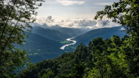
The Arun River flows down from Tibet into Nepal and then merges with two other rivers to become the Kosi
Everest stands on the border between China and Nepal, and its northern part is on the Chinese side. The Arun river flows down from Tibet into Nepal and then merges with two other rivers to become the Kosi which then enters northern India to meet the Ganges.
It is a very high silt-yielding river given the steepness of the mountains it flows through and the force it has, allowing it to carve off so much rock and soil on its way.
But the UCL researchers say it most likely earned its real strength when it “captured” another river or water body in Tibet 89,000 years ago, which in geological timescales is a recent event.
A Chinese academic, Dr Xu Han of China University of Geosciences, was the lead author in the study during a scholarship visit at the UCL.
“The changing height of Mount Everest really highlights the dynamic nature of the Earth’s surface,” he said.
“The interaction between the erosion of the Arun river and the upward pressure of the Earth’s mantle gives Mount Everest a boost, pushing it up higher than it would otherwise be.”
The UCL study says the Arun river most likely gained the capacity to carve off an extraordinary amount of rocks and other materials after it captured another river or water system in Tibet.
Professor Hugh Sinclair with the School of Geosciences at University of Edinburgh, who was not involved in the study, said the underlying process identified by the UCL team was perfectly reasonable.
But, he added, the exact amounts and timescales of river incision (or how the river cuts downward into its bed and deepens its channel) and the consequent surface uplift of surrounding peaks had large uncertainties.
“Firstly, predicting river incision of such large catchments in response to drainage capture (one river capturing another river or lake) is challenging,” he said.
This uncertainty is something the authors have acknowledged in the study.
Secondly, said Prof Sinclair, the distance over which mountains uplift from a point of intensive localised erosion is extremely hard to predict.
“However, even accounting for these reservations, the possibility that some of Everest’s exceptional elevation is linked to the river, represents an exciting insight.”