By The Straits Times | Created at 2026-09-29 04:46:55 | Updated at 2026-09-29 05:15:23
45 minutes ago
By The Straits Times | Created at 2026-09-29 04:46:55 | Updated at 2026-09-29 05:15:23
45 minutes ago
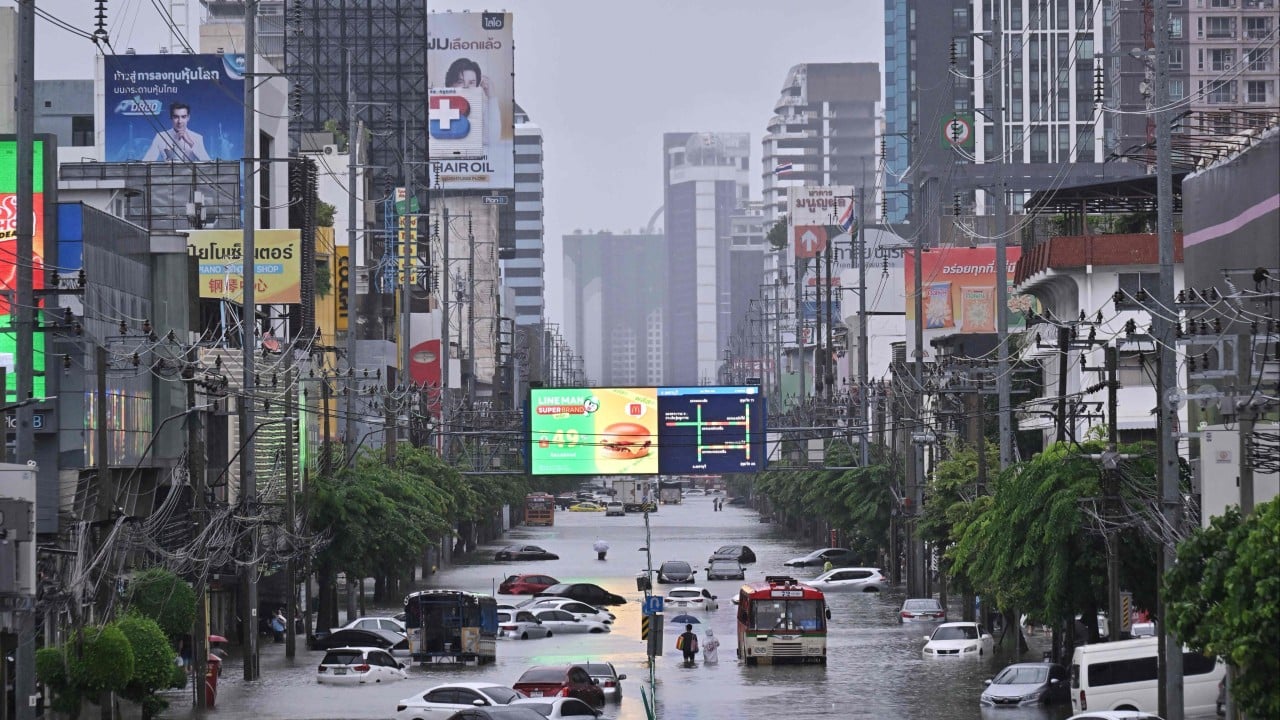
BANGKOK – The intense rainfall over Bangkok and surrounding provinces – widely described in Thai media as a “rain bomb” – has begun to ease, but deep flooding remains in several communities and has renewed scrutiny of the government’s disaster-warning and water-management systems.
The flooding has drawn criticism of Thai Prime Minister and Interior Minister Anutin Charnvirakul’s administration, particularly over the speed of public warnings and assistance to affected communities.
Bangkok recorded close to 300mm of rain over about 48 hours during the worst of the downpour, prompting the city to declare all 50 districts disaster-affected areas.
The criticism has focused not on whether authorities could prevent the extreme rainfall itself, but on whether existing forecasts, data, personnel and emergency resources were brought together quickly enough to reduce damage.
Deputy Prime Minister Songsak Thongsri, who has chaired meetings of the National Water Resources Committee, had said before the heaviest flooding that heavy rain was expected during Sept 24 to 26 but that official assessments did not point to a “mega flood”.
He also questioned warnings circulated by some independent pages and said government agencies were prepared to respond.
The subsequent flooding has therefore raised questions over whether the problem lay solely with unusually severe weather or also with the way agencies interpreted, communicated and acted on available information.
Unlike the 2011 floods, the latest Bangkok crisis was driven largely by intense local rainfall rather than a major mass of upstream water moving into the capital. Nevertheless, roads, homes and vehicles were flooded across parts of the city, particularly in eastern Bangkok.
Part of the attention has turned to Thailand’s recently launched “One Map” water and disaster-information system, which was created specifically to address longstanding problems with fragmented and inconsistent data across government agencies.
The government formally launched the system in September after the Ministry of Digital Economy and Society and the Ministry of Higher Education, Science, Research and Innovation backed an agreement integrating information from four agencies into a single national water and disaster database.
The four agencies have distinct responsibilities.
The Thai Meteorological Department provides observations, forecasts and radar information and is responsible for official warnings on storms and heavy rain.
The Geo-Informatics and Space Technology Development Agency (GISTDA) supplies satellite imagery and geospatial information.
The Hydro-Informatics Institute (HII) provides water-level, flow and telemetry data, as well as 24- and 48-hour rainfall-risk assessments.
The Big Data Institute (BDI) develops analytical systems and dashboards, oversees data governance and applies artificial intelligence to disaster analysis.
The system was promoted as a way to ensure agencies work from the same information and provide the public with clearer forecasts about where flooding could occur, how severe it might be and when water might arrive.
Digital Economy and Society Minister Chaichanok Chidchob currently oversees a ministry that includes the Meteorological Department and BDI.
Long-running attempt to integrate water management
Thailand’s efforts to integrate disaster and water data predate the latest system.
Government policies under earlier administrations called for geographical information systems, shared databases and improved disaster warnings. Following the catastrophic 2011 floods, the Yingluck Shinawatra administration established national water and flood-management bodies and pushed for more integrated information and planning.
A more centralised structure emerged in 2017 with the establishment of the Office of the National Water Resources (ONWR), intended to coordinate national water policy and reduce duplication among agencies.
The current One Map initiative is the latest attempt to address the same underlying problem: government agencies collecting large amounts of useful information but not always turning it into a single, timely message that officials and the public can act on.
Communication becomes key issue
The latest flooding has put particular emphasis on how warnings are communicated.
Official notices can sometimes be technical or bureaucratic, while independent weather pages may communicate faster and in language that is easier for the public to understand.
That contrast became politically sensitive before the flooding when government figures questioned the reliability of warnings from unofficial pages. Songsak said on Sept 23 that some online claims of a catastrophic flood risk could unnecessarily alarm the public and stressed that the Meteorological Department remained the official authority.
The government’s own One Map announcement had identified inconsistent and fragmented information as a weakness that had previously delayed decision-making and public preparation.
The question now is whether the large volume of available data can be converted quickly enough into simple warnings that tell residents what is likely to happen and what action they should take.
Responsibility for flood management is spread across several agencies.
Water management involves several layers of government
ONWR coordinates national water planning and assesses flows and reservoir management, while the Interior Ministry and the Department of Disaster Prevention and Mitigation are central to emergency response, warnings and evacuation at provincial and local levels.
The military generally provides supporting personnel and equipment when civilian agencies request assistance.
The source analysis also raises questions over whether administrative changes inside the Interior Ministry and the transition between fiscal years may have affected coordination. That remains an interpretation rather than an established cause of the response problems.
Bangkok administration also faces questions
The Bangkok Metropolitan Administration (BMA) has also faced criticism over whether canal levels were lowered sufficiently before the heaviest rainfall.
Suchatvee Suwansawat, leader of the Thai Kao Mai Party, publicly questioned why canals had not been brought to their lowest possible levels earlier, arguing that pumping after canals were already overflowing was too late.
However, BMA reports show that Governor Chadchart Sittipunt had ordered water levels lowered in major canals ahead of the forecast heavy rain, including Khlong Lat Phrao, Khlong Prem Prachakorn, Khlong Saen Saep and Khlong Prawet Burirom. The city also diverted water into Nong Bon retention areas and ran pumping stations at high capacity.
Suchatvee nevertheless argued that the measures were insufficient and that water had not moved efficiently through the canal network towards major pumping stations.
Floods expose coordination challenge
The episode therefore highlights a broader challenge extending beyond rainfall intensity itself.
Thailand now has forecasting technology, national databases, satellite information, telemetry, emergency agencies and major drainage infrastructure. The policy question raised by the flooding is how effectively those resources are connected from forecast to warning, from warning to operational decisions, and from those decisions to assistance on the ground.
The government introduced One Map with the stated aim of making disaster information more unified, accurate and easier to act upon.
The Bangkok floods have provided an early real-world test of that ambition – and have intensified calls for authorities at both national and city level to ensure they can identify risks earlier, issue warnings in time and respond quickly enough to limit damage. THE NATION/ASIA NEWS NETWORK