By Science Daily (Science) | Created at 2026-10-13 13:45:53 | Updated at 2026-10-13 17:19:18
17 hours ago
By Science Daily (Science) | Created at 2026-10-13 13:45:53 | Updated at 2026-10-13 17:19:18
17 hours ago
Just two weeks after reaching orbit, Europe's new Copernicus Sentinel-3C satellite has delivered its first spectacular images of Earth, revealing everything from the snow-covered Alps to the frozen Arctic and the brilliant turquoise waters of the Caribbean.
But the satellite is doing much more than taking beautiful pictures. Its instruments have also begun measuring ocean heights and the elevation of Greenland's massive ice sheet, providing an early demonstration of technology designed to monitor Earth's changing climate.
The first images and measurements come from two of Sentinel-3C's key instruments. Both are performing well in initial tests, bringing the satellite closer to its mission of tracking environmental changes across the planet.
A Powerful New Satellite to Monitor Earth's Changing Climate
Sentinel-3C is the third spacecraft in Europe's Sentinel-3 satellite series, a central part of the Copernicus Earth observation program. The satellites are equipped with matching sets of instruments that continuously gather information about the oceans, land, atmosphere, and cryosphere, which includes Earth's frozen regions.
Over the oceans, Sentinel-3 measures sea surface temperature, color, and height, along with sea ice thickness. These observations help scientists investigate marine pollution, track marine heatwaves, and understand changes in ocean conditions.
On land, the mission provides valuable information about droughts, wildfires, vegetation health, and how different areas are being used. It also measures water levels in rivers and lakes, as well as changes in the elevation of polar ice sheets.
The data support weather forecasting by providing timely observations of environmental conditions. They also help researchers identify long-term trends linked to climate change.
The European Space Agency (ESA) is still preparing Sentinel-3C for full operation through a detailed testing and commissioning process expected to take another five months. Nevertheless, the satellite's first two weeks in orbit have already produced encouraging results.
Stunning Satellite Images Reveal Italy's Diverse Landscape
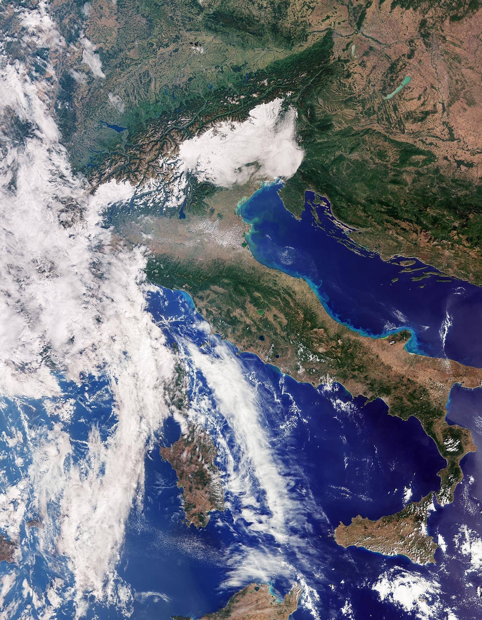
One of Sentinel-3C's first images, captured on September 30 by its ocean and land color instrument, offers a remarkable natural-color view of Italy and its surrounding seas.
The image extends from southern Germany across the Italian peninsula to Sicily and the southern Mediterranean. It reveals an extraordinary variety of landscapes, from towering mountains and fertile farmland to deep blue waters.
Near the upper center of the scene, the Po Valley stands out as a broad expanse of green and brown. This fertile region is the heart of Italy's agricultural production. Immediately to the north, the snow-covered Alps rise dramatically above the lowlands, their bright white peaks creating a striking contrast with the surrounding terrain.
Elsewhere across Italy, different shades of green and brown reveal variations in vegetation, farming activity, and land cover.
To the east, the Adriatic Sea separates Italy from the partially visible Balkan Peninsula. Along Italy's eastern coast, bands of lighter blue water stand out against the deeper blue offshore. Scientists believe these color differences are likely caused by sediment carried into the sea by rivers and redistributed by coastal currents.
On the opposite side of the peninsula, the dark waters of the Tyrrhenian Sea surround Sardinia and Sicily. Corsica is also within the image, although clouds obscure much of the island.
Together, the contrasting colors of mountains, farmland, islands, and surrounding seas create a vivid portrait of Italy as seen from space.
A Dramatic View of the Arctic's Vulnerable Ice
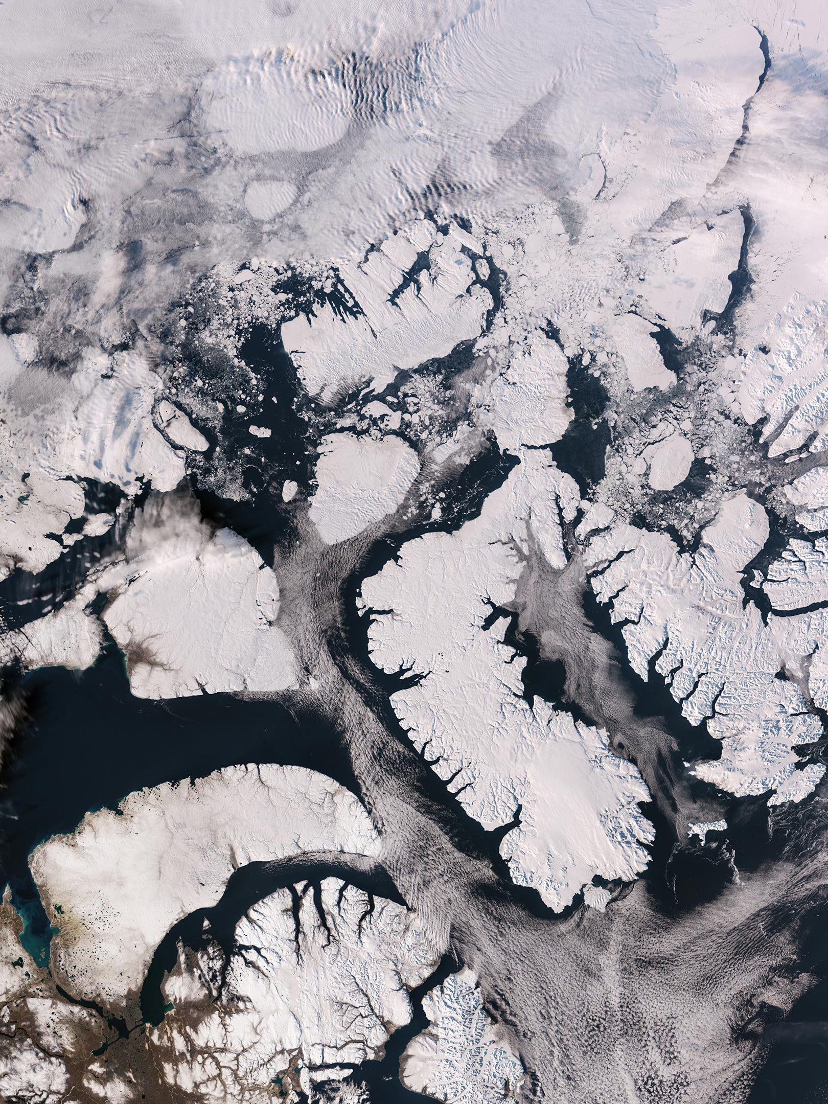
Another image captured on September 30 shifts the focus far north to the Canadian Arctic Archipelago, located west of Greenland.
Here, the landscape looks dramatically different. Snow and ice blanket many of the islands, while exposed rock, rugged coastlines, and deep fjords form intricate patterns across the frozen region.
The image was taken near the time of year when Arctic sea ice typically reaches its annual minimum. Much of the surrounding water appears dark and open, although scattered fragments of floating sea ice remain visible.
These observations are particularly important because the Arctic is warming much faster than the global average.
As temperatures rise, glaciers and ice sheets lose mass, while sea ice continues to melt. The disappearance of reflective ice also exposes darker ocean water, which absorbs more solar energy and can accelerate regional warming.
Sentinel-3's different instruments observe ice in complementary ways, helping scientists better understand changes across these vulnerable polar environments.
Brilliant Caribbean Waters Seen From Space
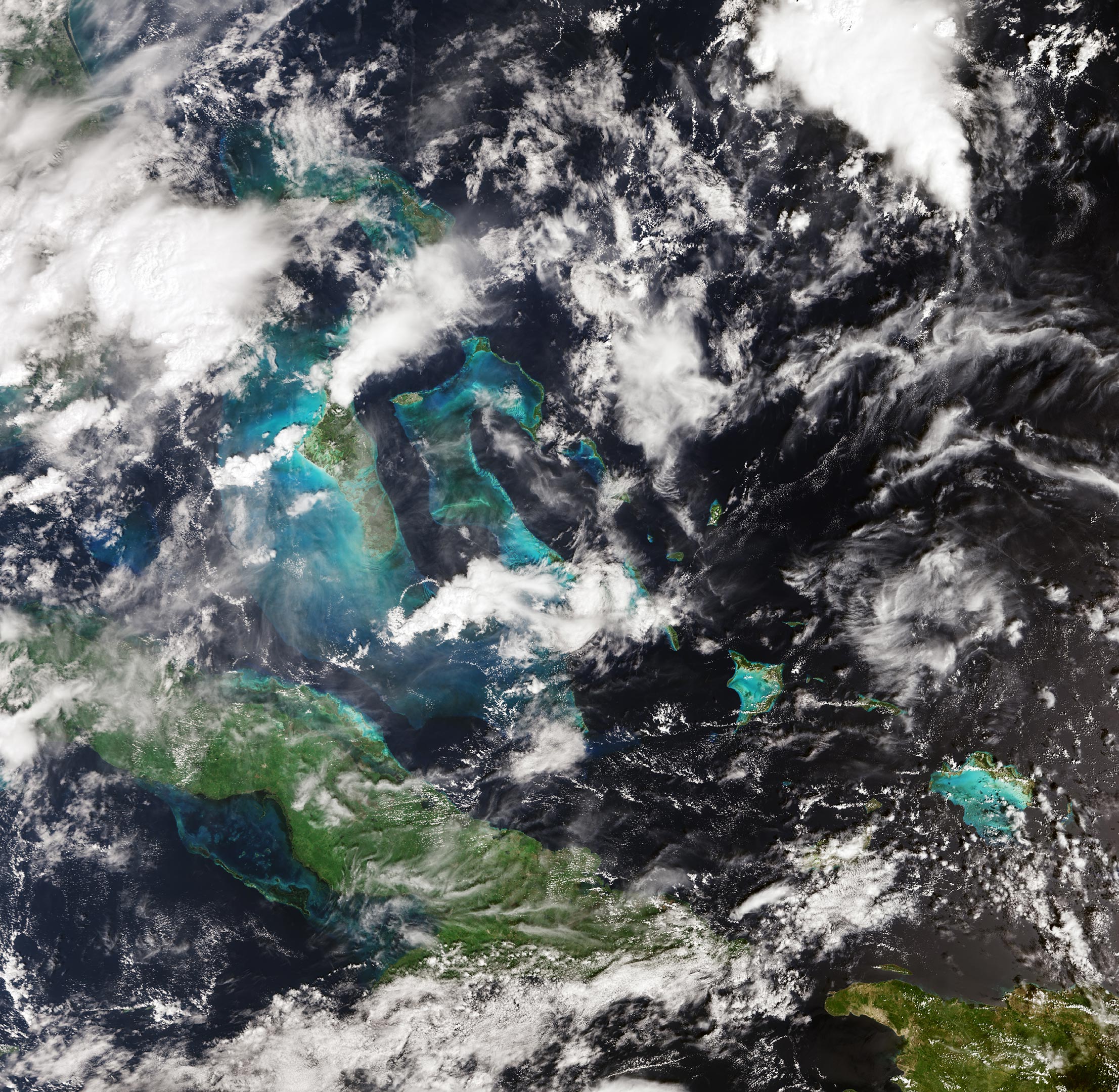
Sentinel-3C's third featured image, captured on September 29, reveals an entirely different side of Earth.
The scene shows part of the Caribbean, with Cuba near the bottom and the Bahamas toward the top. Around the islands, shallow waters glow in brilliant shades of turquoise, contrasting sharply with the dark blue of the deeper surrounding ocean.
These dramatic differences in color help reveal variations in water depth and the characteristics of the marine environment.
The Caribbean image is also a reminder of the challenges facing low-lying islands and coastal communities as global sea levels continue to rise.
One of Sentinel-3C's most important instruments, its synthetic aperture radar altimeter, is designed to measure the height of the ocean surface with high precision. By tracking how that height changes over time, scientists can better understand sea-level rise and support efforts to prepare for its consequences.
New Measurements Show the Satellite Is Performing Well
Beyond its striking photographs, Sentinel-3C has already begun demonstrating its ability to gather precise scientific measurements.
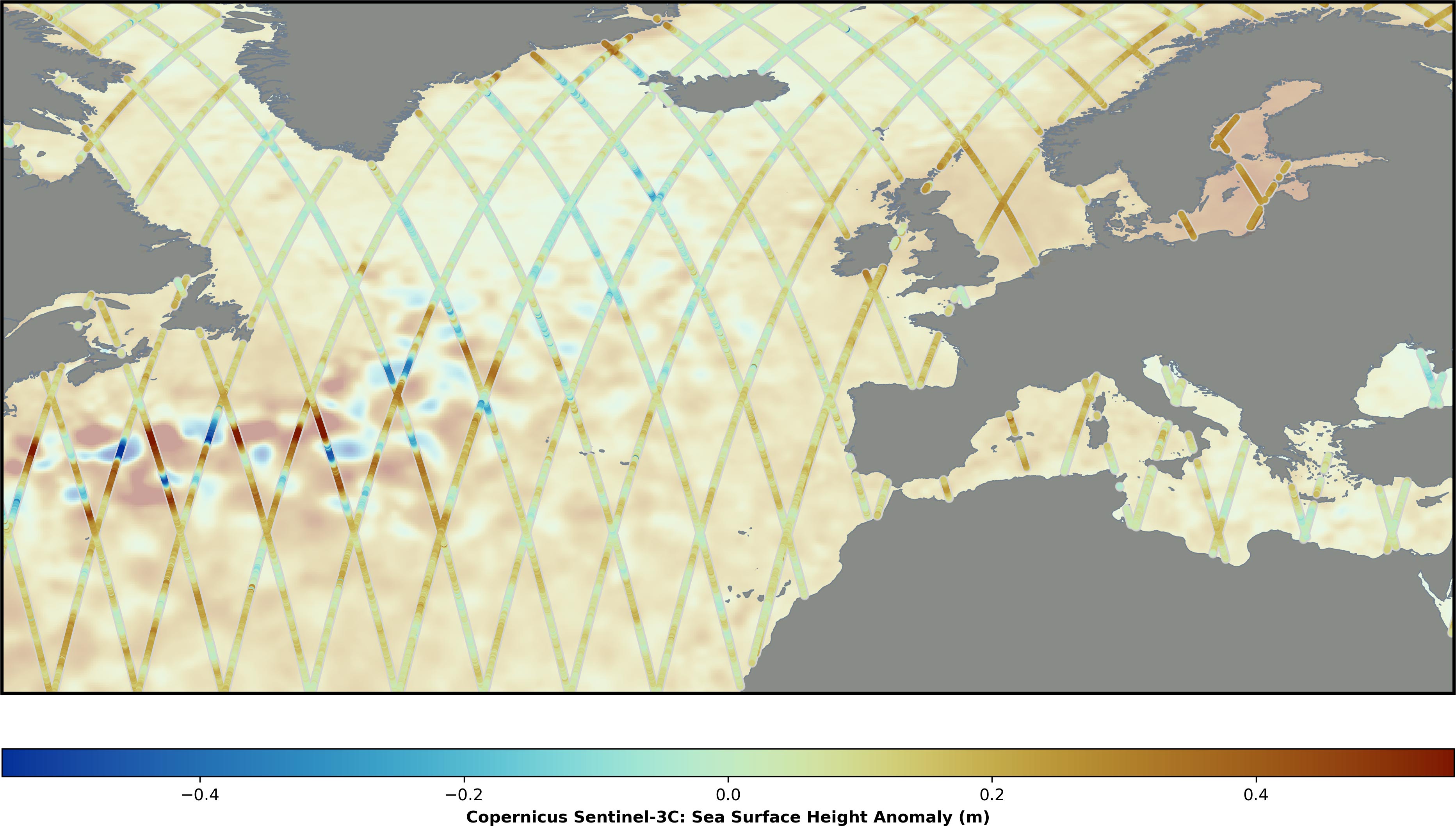
Its radar altimeter has collected sea surface height data across the Atlantic Ocean and Mediterranean Sea. Researchers compared these observations with the Copernicus Marine Service's multimission sea-level anomaly data, which combine measurements from multiple satellites.
The early results show good agreement with existing measurements, indicating that the new altimeter is operating as expected.
Once Sentinel-3C completes commissioning, it will contribute to global sea-level monitoring alongside established satellite missions such as Copernicus Sentinel-6 and Jason.
These long-running observations are essential for understanding how quickly the world's oceans are rising.
Thanks to precise satellite measurements, scientists have determined that global sea levels have increased by an average of 3.64 mm per year since 1999. The rate of sea-level rise has also been accelerating, making continued monitoring increasingly important.
Sentinel-3C's altimeter will contribute more than ocean measurements. It will also observe changes in the height of rivers, lakes, sea ice, and land ice, complementing future observations from the upcoming Copernicus CRISTAL mission.
Tracking Greenland's Massive Ice Sheet From Orbit
Some of Sentinel-3C's most encouraging early results come from Greenland.
Between September 30 and October 4, the satellite collected measurements of the Greenland Ice Sheet's surface elevation. An accompanying animation shows the tracks of these observations across the enormous ice-covered landscape.
When scientists compared the measurements with a reference digital elevation model, a detailed representation of the ice sheet's surface, the satellite's observations closely matched the existing data.
This agreement offers further evidence that the radar altimeter is functioning properly.
Accurately tracking ice sheet elevation is particularly important as the planet warms. Greenland and Antarctica contain vast amounts of frozen water, and changes in their ice sheets can have major consequences for global sea levels.
Ice loss from these regions is already a major contributor to sea-level rise. By repeatedly measuring the height of their surfaces, satellites can help scientists monitor changes over time and improve predictions of future sea-level rise.
What's Next for Europe's New Earth-Watching Satellite?
Although Sentinel-3C is still in its early testing phase, its first observations represent an important step toward full scientific operations.
The satellite's ocean and land color instrument has already delivered detailed images of landscapes and coastlines, while its radar altimeter has produced encouraging measurements of ocean and ice sheet elevations.
Another milestone is approaching. The mission is preparing to release the first observations from its sea and land surface temperature radiometer, an instrument designed to measure the temperature of Earth's land and ocean surfaces.
Sentinel-3C is part of Copernicus, the Earth observation component of the European Union's Space Program. ESA is responsible for developing and implementing the Sentinel-3 satellites and operating them through the commissioning period.
After commissioning, ESA and the European Organisation for the Exploitation of Meteorological Satellites (Eumetsat) jointly manage the Sentinel-3 mission.
Eumetsat handles routine satellite operations and supplies marine and atmospheric observations, while ESA provides data covering land, the cryosphere, inland waters, and atmospheric products processed after acquisition.
Together, the two organizations make Sentinel-3 observations available to Copernicus services and users around the world.
With its first images and measurements already demonstrating promising performance, Sentinel-3C is on its way to becoming another important tool for observing Earth's oceans, landscapes, ice sheets, and atmosphere as the planet continues to change.