 By Axios | Created at 2024-09-24 15:33:56 | Updated at 2024-09-30 07:29:10
5 days ago
By Axios | Created at 2024-09-24 15:33:56 | Updated at 2024-09-30 07:29:10
5 days ago
A potentially landmark, highly destructive tropical cyclone is brewing in the western Caribbean. It is forecast to become Tropical Storm, and then Hurricane Helene during the next 24 hours.
Threat level: The storm, which has been slow to organize over the far western Caribbean, is expected to rapidly intensify once it develops an well-defined center of circulation and moves into the southeastern Gulf of Mexico.
- Helene's anticipated large size would put the entire state, including Miami, Orlando, Tampa and Jacksonville in play for damaging winds and heavy rains.
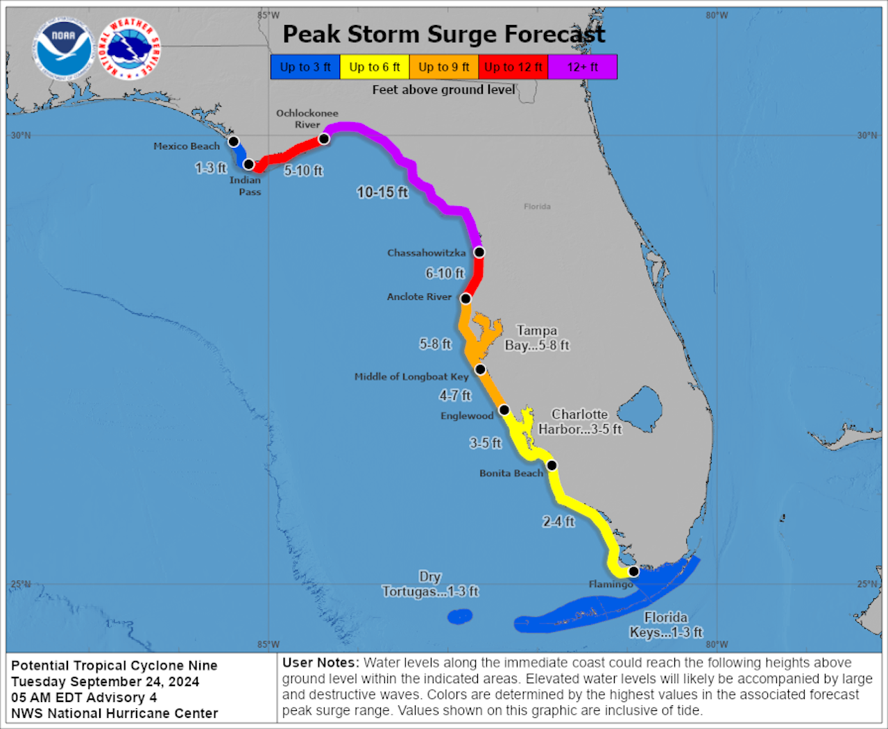
- The storm surge threat is particularly acute in Tampa Bay, where a 5-to-8-foot surge above normally dry land is predicted if the storm hits at high tide.
Computer models have consistently flagged the likelihood that the storm will increase dramatically in intensity and size as it makes its way north-northeastward toward an expected landfall as a "major" Category 3 storm — or possibly stronger — on Thursday evening.
- The most likely landfall location is somewhere between the Florida Panhandle and the state's Big Bend region on Thursday evening.
- The high intensification rate is due in large part to record-hot ocean surface temperatures in the Gulf of Mexico along with ocean heat content values that are also in rare territory — indicating the presence of warm water well beneath the Gulf's surface.
Zoom in: Helene is forecast to bring high winds, heavy rains and a damaging storm surge to a broad stretch of the west coast of Florida, from the Keys northward.
- Any track shift east, even by 10 to 20 miles, would further amplify the already significant surge hazard the heavily populated, low-lying region is facing.
- A surge of 10 to 15 feet is forecast for the Big Bend region, where the curve of the land amplifies the surge potential.
State of play: Tropical storm, hurricane and storm surge watches are now in effect for large parts of Florida.
- Florida Gov. Ron DeSantis declared an emergency in 41 counties ahead of the expected arrival of the storm.
Tuesday morning: Hurricane and tropical storm watches are scattered along the full length of #Florida, from the Keys up to the panhandle, ahead of future-#Helene. It's not even a tropical depression yet, but don't let that fool you!! #PTC9 pic.twitter.com/RGMfGNTZls
— Brian McNoldy (@BMcNoldy) September 24, 2024Context: Climate change is boosting global ocean temperatures, which were at record-high levels for more than a year straight.
- According to data from the nonprofit research group Climate Central, human-caused climate change made the current record-warm waters of the Gulf of Mexico between 200 to 500 times more likely.
- There has been a documented trend toward more storms that rapidly intensify, and an amplification of the intensification rates in the Atlantic as well.
The big picture: The Atlantic hurricane season was forecast to be hyperactive due to record warm ocean temperatures and the formation of a La Niña event in the tropical Pacific Ocean. However, other factors have stifled storm activity for long periods.
- Still, this would be the fourth hurricane to make landfall in the U.S. so far this season, and the eighth hurricane landfall in Florida since 2016.
- The frequent hurricane hits have caused many insurers to flee the state and driven up prices for homeowners.
The bottom line: All signs show that this storm could be a significant multibillion-dollar disaster, depending on how close it comes to the more heavily populated parts of Florida's west coast.