 By The Epoch Times | Created at 2026-07-21 14:31:40 | Updated at 2026-08-09 07:31:02
2 weeks ago
By The Epoch Times | Created at 2026-07-21 14:31:40 | Updated at 2026-08-09 07:31:02
2 weeks ago
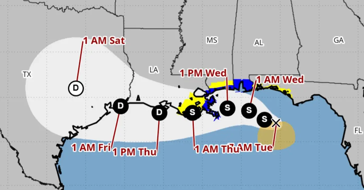
A tropical storm warning, in blue, is in effect from the Alabama-Florida border to the border of Louisiana’s Jefferson and Plaquemines parishes, according to a forecast map for Tropical Storm Bertha issued by the United States on July 21, 2026. (National Hurricane Center.
The National Hurricane Center (NHC) on Tuesday morning issued tropical storm warnings and advisories for a swath of the Gulf Coast—from the Florida Panhandle to Louisiana—as Tropical Storm Bertha churned off the coast of Florida.
A tropical storm warning was in effect from the Alabama–Florida border to the border of Louisiana’s Jefferson and Plaquemines parishes, the NHC said in an update released at 8 a.m. ET.
A tropical storm watch was issued for the border of Bay and Gulf counties in Florida westward to the Florida–Alabama border, as well as from west of Louisiana’s Jefferson and Plaquemines parishes to Morgan City, Louisiana. Watches are also in effect for metropolitan New Orleans, Lake Pontchartrain, and Lake Maurepas in Louisiana.
A warning means tropical storm conditions will be expected within the next 36 hours, while a watch means tropical storm conditions are possible in the next 24 to 48 hours.
The storm was expected to remain near or along the northern Gulf Coast this week, likely dropping heavy rain across coastal areas of Florida, Alabama, Mississippi, and Louisiana as it moved westward toward Texas, according to the NHC.
The storm was about 100 miles south of Panama City, Florida, and 175 miles southeast of Mobile, Alabama, and moving northwest at 5 mph with maximum sustained winds of 50 mph, the hurricane center said Tuesday. The wind speed has increased by 10 mph since Bertha formed Monday night.
According to the agency’s modeling, Bertha is not expected to strengthen into a hurricane. A Category 1 hurricane has wind speeds of at least 74 mph.
After the storm reaches eastern Louisiana, it is expected to be downgraded into a tropical depression before it moves just south of much of the state’s southern coastline. The depression is then forecast to hit southeastern Texas before moving east–northeast over the state by Saturday.
A storm surge watch, indicating rising, possible life-threatening water moving inland from the coast within 48 hours, was issued from the Alabama and Florida border to the mouth of the Mississippi River, the NHC also said Tuesday.
Bertha is the second tropical storm of the Atlantic hurricane season, following Tropical Storm Arthur, which brought heavy rainfall to the southeastern United States in June.
Hurricane Fausto Poses No Threat to Land
In the eastern Pacific Ocean, Hurricane Fausto churned far from Mexico’s Baja California peninsula and posed no threat to land, the hurricane center said Tuesday. No coastal watches or warnings were in effect.
Fausto gained hurricane status on Monday night, and it is about 740 miles southwest of the southern tip of the Baja California peninsula. It has top sustained winds of 80 mph and is moving 12 mph to the northwest.
The storm was expected to strengthen Tuesday and Wednesday, potentially reaching near major, Category 3 hurricane status, officials said. Ocean swells generated by the storm could cause life-threatening surf and rip tide conditions on the Baja California coast, the center said.
The Associated Press contributed to this report.